Utility Mapping

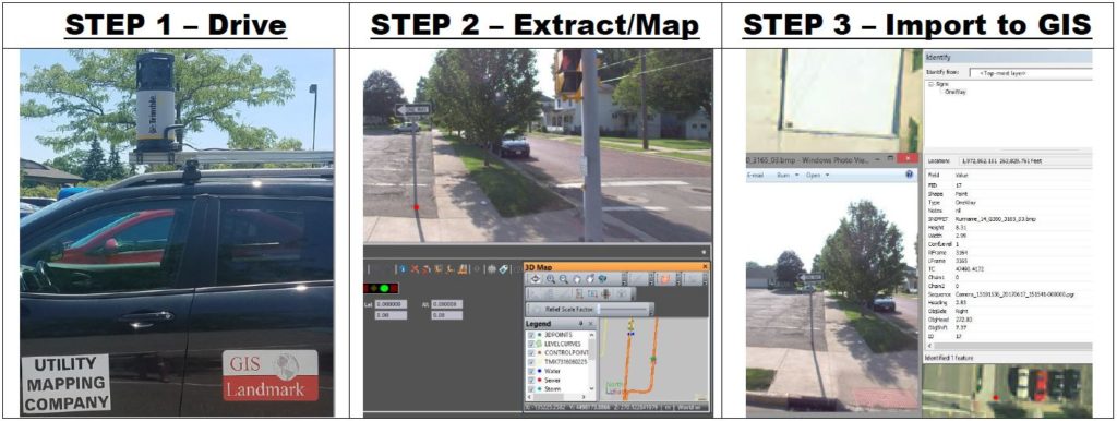
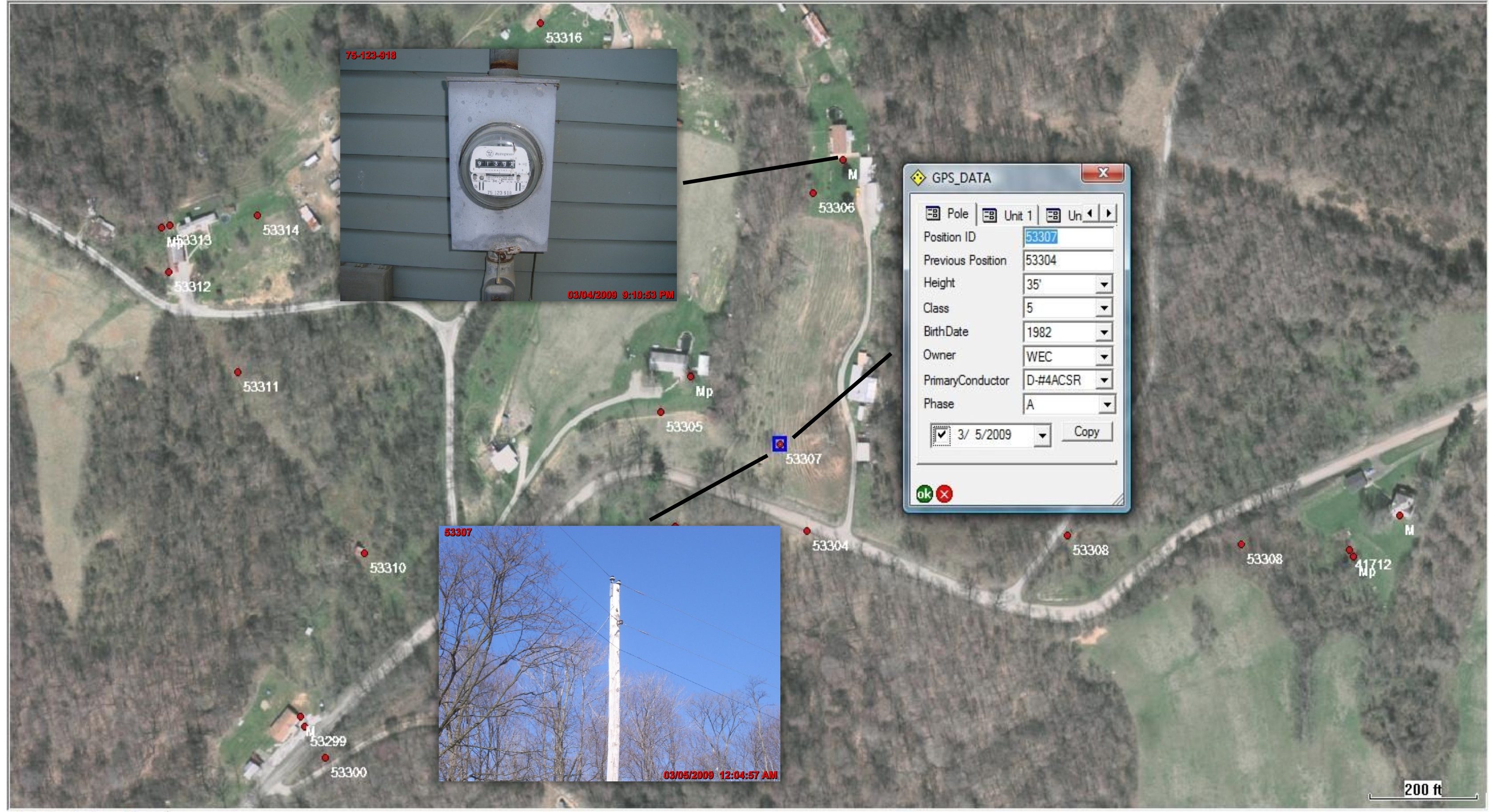
GIS Landmark provides GIS and Utility Mapping Services to Municipals, Villages, Cooperatives and Companies worldwide! We have over 25 years of experience in the GIS & utility mapping industry. GIS Landmark has all the tools and experience to provide the highest accuracy and quality end product for your utility mapping needs! We use all the latest hardware and software for GPS, GIS and utility mapping. Please contact us today to see all of our amazing services we offer along with info on our mobile mapping services. www.gislandmark.com

GIS Utility Mapping

Home

ByAndrew Salyers

Sep 13, 2019


GIS Landmark, LLC specializes in Automated Mapping / Facilities Management Systems (AM/FM) and Geographic Information Systems (GIS) for utility mapping projects worldwide. We offer AM/FM/GIS services to various utility companies covering the areas of gas distribution/transmission, electric distribution/transmission, telecommunications, cable and water/sewer. Our highly trained professionals have the knowledge to blend the technologies of digital mapping from variety of sources including satellite images, aerial photographs, GPS field data and existing maps leading to the GIS database creation.

Today, most utilities that haven’t considered AM/FM/GIS in the past are now doing so because of the threat of competition and being able to respond to public, regulatory, and legislative inquiries that are geographic in nature. A GIS utility mapping system can arm utilities with the tools to compete efficiently, identifying where revenue is coming from compared to where facilities are located. GIS Landmark can implement data conversion, spatial data processing, GIS database creation, analysis and modeling for your utility mapping project. Please allow GIS Landmark an opportunity to speak with you about your GIS project. Thanks for visiting our website!
About GIS Landmark

MOBILEMAPPING SERVICE

GIS Utility Mapping

Our Team

At GIS Landmark, Our team of experts help transform your ideas and goals into a GIS to use for years to come.

TESTIMONIALS

“During an 18 month period GIS Landmark accurately and efficiently collected information at over 60,000 data points. We found that their professionalism and courtesy to land owners resulted in great consumer relations as they crossed properties in 9 counties. They required limited supervision and reported their location at our request.”
Guernsey-Muskingum EC
New Concord, Ohio
“GIS Landmark has proven to be a great solution for our AMI project manpower needs. Their personnel are very customer friendly, mature, knowledgeable and courteous. GIS has met all of our deadlines and works well with our electric cooperative in providing daily progress reports, meter exchange information and additional distribution system information requested by the cooperative. Several field audits have proven that the field employees work in a safe manner, use proper PPE and report hazardous conditions.”
Forest Rose
The Energy Cooperative
"GIS Landmark provides a great service to the City of Bowling Green designing and implementing our electric, water, sewer and storm service mapping/GIS. We could not have accomplished a project of this size in such an efficient, effective manor without GIS Landmark.”
Jason Heyman
City of Bowling Green, Ohio
“Logan County Electric Cooperative has been associated with GIS Landmark for several years. They have been a big help to our cooperative in implementing GIS into our utility mapping system. GIS Landmark has done GPS field inventory, joint use audits, database manipulation and wall and truck maps for our cooperative. They also worked well with NISC with the data import process. The associates of GIS Landmark are very knowledgeable, friendly and very helpful to work with. We would recommend GIS Landmark for any of your GIS needs.”
Scott Roach
Logan County Electric Cooperative